 |
| South American Agriculture |
Increasing urbanization in South America raises questions regarding use of both land that is farmed and land that is abandoned.
In South America as elsewhere, land forms, soil, water, climate, and culture interact to produce an arrangement of agricultural production specific to the region.
South America can be divided into six general land form regions: the Andes Mountains, the plateaus of the interior of the continent, the river lowlands, the coastal lowlands, the tierra templada, and the tierra fria.
  |
Andes Mountains
The Andes Cordillera reaches from Venezuela in the north to Tierra del Fuego at the south tip of the continent. Some Andean peaks exceed 20,000 feet (6,100 meters) in height.
The mountain soils are rocky and steeply graded. This makes farming difficult but not impossible. Farmers use terrace systems, building up step like fields carved into the side of a mountain.
Because of the limitations of the soils and the difficulty in farming them, the region supports only subsistence agricultural settlements. People in the highlands grow small plots of corn, barley, and especially potatoes on the high-altitude soils.
Highland Growing Regions
 |
| coffee-growing region |
In the central eastern region of Brazil are the Brazilian Highlands. To the north of the Amazon basin lies another plateau region called the Guiana Highlands.
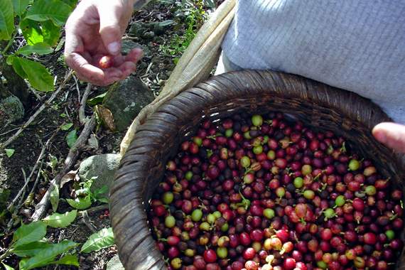
Both plateaus, which are not much higher than 9,000 feet (2,743meters), are old geologic structures with relatively rough surfaces to farm. The Brazilian Highlands constitute the world’s primary coffee-growing region.
More than one-third of the world’s coffee is grown there, along with soybeans and oranges. The Guiana Highlands, which stretch through southern Venezuela and Guyana, are covered in savannas (grasslands with trees and shrubs). People there use slash-and-burn agriculture to grow corn and rice.
River Lowlands
Some of the most remote regions in South America are its fastest-developing areas. The northern interior of Brazil in the Amazon basin is covered with the world’s largest tropical rain forest, the size of the forty-eight contiguous United States.
Within some areas of this rich habitat, gold and huge iron ore deposits have been discovered. Development programs have encouraged mining, hydroelectric projects, ranching, and farming there.
This has produced a need for clearing the forests and caused a large migration of people into this otherwise remote, isolated region. It has been estimated that 30,000 square miles (78,000 square kilometers) of tropical rain forest were destroyed annually in the 1990’s.
 |
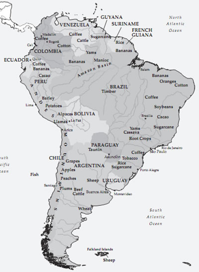
| South American Agriculture Map |
The rain forest is not a highly productive growing region for crops. Soils there are thin and have few nutrients. To grow crops and grasses for cattle, slash-and-burn agriculture is practiced.
Trees and brush on the land are cut down and burned, and the ashes enrich the soils for a time. This allows for limited production of crops such as corn and rice, but after about three years the nutrients are washed out of the soil by the heavy tropical rains.
Farmers and ranchers move on and find new forest area to cut, and the cycle goes on. Rain forests cover only about 5 percent of the total land area of the earth but contain more than half the different types of plants and animals on earth. These forests provide lumber products, medicines, and food.
The Orinoco River drains the Guiana Highlands and the llanos region of Venezuela, flowing into the Atlantic Ocean. The llanos form a large, expansive plain of grassland between the Andes in Venezuela and the Guiana Highlands. Soils are flooded in this area during the rainy seasons, providing for rich grass development and the support of large cattle ranches.
   |
The Amazon River drains the north and western region of Brazil. Although more water moves through the Amazon River than any other river in the world, its location in dense tropical forests under a humid tropical climate makes agriculture there a challenge.
Amerindians of the region practice subsistence agriculture, growing yams and bananas and raising some small animals. Cassava, or manioc (a root crop from which tapioca is made) and sugarcane are also grown there in slash-and- burn fashion.
The Paraná, Paraguay, and Uruguay Rivers, south of the Amazon lowlands, dissect a great grassland region known as the Pampas and a forested region known as the Gran Chaco, which extends to northern Argentina. The Pampas is not unlike the Midwest of North America.
It is a huge grassy plain nearly 400 miles (640 kilometers) long in the central part of Argentina. Agriculture is the primary industry in Argentina and encompasses 60 percent of the country’s land. Large estancia (cattle ranches) are common in the region.
The soils are well suited to wheat and other grains as well as alfalfa, a grass grown for cattle and horse feed. The level character of the land makes it easy to work, but it is difficult todrain andis prone to flooding.
Paraguay’s agricultural zones are divided by the Paraguay River. Tobacco, rice, and sugarcane grow to the east of the river in the more humid climates.
To the west, in the drier climates and the Chaco region, is the unique growing area of the Quebracho Forest. Quebracho is a hardwood that grows only in the Chaco. The wood contains tannin, which is used to produce tannic acid, a chemical used for tanning leather.
This area is suited for cattle, but because of its rocky and steep topography, the population of goats and sheep rises as one moves farther west toward the Andes. Irrigated with mountain streams from the eastern slopes of the Andes, grapes also grow well and are made into wine.
Coastal Lowlands
 |
| Sugarcane plantation in Brazil |
The coastal lowlands, up to an altitude of about 2,500 feet (750 meters), encompass an area known as the hot land (tierra calienta). Temperatures there average between 75 and 80 degrees Fahrenheit (22 and 24 degrees Celsius), and plantation agriculture abounds.
Plantations are huge commercial farming operations that grow large quantities of crops that are usually sold for export. Because of their easy access to port facilities, coastal lowlands historically have been linked with the markets of Europe and North America.
The banana is one of the best-known examples of a plantation crop. It grows well in the wet, hot climate of this zone and has been cultivated there for U.S. and European markets since 1866.
In the 1990’s, more bananas were traded on the international fruit market than any other commodity. In South America, Ecuador and Brazil are the leading banana producers, with Colombia third.
Cacao, the bean pods from which cocoa and chocolate are made, is also grown on plantations in this zone. The largest producing area for cacao is Ghana in West Africa, but Brazil and Ecuador are fifth and sixth in world yearly production.
Although sugarcane is grown in almost every country in South America, it does well as a plantation crop in the lowlands of eastern Brazil, the world’s largest exporter.
There the crop is not used just to produce sugar but also to produce ethanol for gasohol, an alcohol-based gasoline that fuels more than half the automobiles in Brazil.
This type of commercial agriculture has made agricultural business the fastest-growing part of the Brazilian economy. Yams, cassava, and other root crops used as staple foods also growwell in this humid, hot climate.
Tierra Templada
Just above the calienta zone lies a zone of cooler temperatures, the tierra templada, that extends to about 6,000 feet (1,850 meters). Temperatures there range from 65 to 75 degrees (17 to 22 degrees Celsius), and the commercial crop that dominates the landscape is coffee.
It is grown on large plantations called fazendas. Brazil, the largest South American coffee producer, exports about one-quarter of the world’s coffee, producing nearly fortymillion bags of about 132 pounds each (60 kilograms) annually.
Colombia is South America’s second-largest coffee producer. Coffee was once the leading export from Colombia, but as a result of a coffee-worm infestation and lower world prices, other products are taking the lead.
Other commercial crops from this zone include fresh fruit. In the central valley of Chile, grape vineyards and apple orchards have emerged. Produce from this region enters stores in the United States and else where as the growing seasons of the domestic products are finishing up.
Chilean grapes, apples, peaches, and plums are now sold world-wide. Corn and wheat are also grown in this zone. These staple foods are produced for local consumption and sold only at local markets.
Tierra Fria
A cooler climate, the tierra fria, extends from 6,000 feet (1,850 meters) to about 15,000 feet (4,570 meters). Average temperatures there range from55 to 64 degrees Fahrenheit (12 to 17 degrees Celsius).
This zone extends throughout the Andes and can maintain only that plant life that can withstand the limited soils and the cold conditions. In this region of subsistence-type farming, crops and animals are grown and raised mostly for family use.
In the lower reaches of this zone, barley grows well because it requires a short growing season. In the cooler portions of this zone, the potato began.
A tuber, the potato can flourish in cold conditions with moderate moisture. The loose soils of this zone are perfect for its production, but it requires a considerable amount of cultivation.
Although the potato is used throughout South America, potato production for the continent constitutes only about 5 percent of the world total production. Alpacas, a type of goat, and llamas are also raised there.